Weather: How It Happens
How It Happens
The hurricane story begins with a cluster of thunderstorms set off in the tropics, usually by some type of surface convergence. These initial squalls frequently develop in western Africa and move westward into the Atlantic. (The following figure shows a pattern of global winds that frequently provides for that initial convergence.) The organized area of convection then releases heat, which lowers the pressure. The lower pressure forces more air to converge and, as it comes together, the air is forced to rise. This rising motion causes more huge thunderstorms that release more heat and reduce the pressure even more. That, in turn, allows more air to converge near the ground.
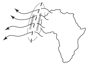
Hurricane formation.
Remember the Coriolis force from "Going in Circles"? That's the force that makes the weather spin when air is put into motion. As more air rises, more air rushes toward the center, and the circulation becomes greater and greater.
Weather-Wise
The hurricane season officially begins June 1.
There also has to be some mechanism for removing the air at high levels, which will ensure a steadily falling pressure through the net removal of the air. More air will leave than arrive. A high-pressure system aloft with diverging currents will do the job. Lots of tropical disturbances will form, but only a few will make a name for themselves. Usually that high-level exhaust fan is missing with those storms that fail to make it. The next figure shows how the entire pattern evolves.
When a disturbance forms with a well-defined circulation but winds under 39 mph, the system is called a tropical depression. When the wind reaches 39 to 73 mph, the system is called a tropical storm. When the wind exceeds 73 mph, the circulation is classified as a hurricane. In the western Pacific, hurricanes are called typhoons. In the Indian Ocean, they are called cyclones. But in general, tropical cyclones refer to all organized tropical circulations.
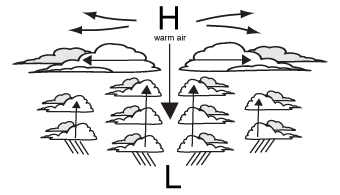
Hurricane development.
These tropical cyclones have a unique structure (shown in the figure below). A hurricane's circulation covers an area of about 300 to 700 miles. Moisture spirals into the center along spiral rain bands. The heaviest rain and the most violent weather will occur within these precipitation bands. The winds gradually increase toward the center of the hurricane. The highest winds are found in the eye wall, where towering clouds extend up to 50,000 feet and higher. The most destructive portion of the hurricane occurs in the eye wall.
Weather-Speak
When a system has winds under 39 mph, it's called a tropical depression. When the wind reaches 39 to 73 mph, the system is a tropical storm. When the wind exceeds 73 mph, the circulation is classified as a hurricane. In the western Pacific, hurricanes are called typhoons; in the Indian Ocean, they're called cyclones. A tropical cyclone generally refers to all organized tropical circulations.
At the center is the relatively calm eye, where the wind may be about 10 to 15 mph. Air is subsiding into the eye, which is why the sky is clear. The rain will end, and the clouds will be broken. The eye itself is about 10 to 30 miles wide. Because tropical cyclones release tremendous amounts of heat, the center of the circulation is warmer than the surroundings, another characteristic that distinguishes these storms from frontal cyclones. Storms that form on fronts have a cold center.
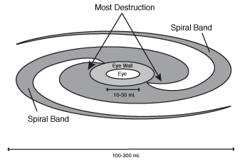
Hurricane structure.
These storms need energy, which limits the areas where they can develop. They have to form over the oceans, in locations where the water temperature is at least 79 degrees. If the water temperature is lower, the storm will actually lose energy to the ocean surface. That's why a hurricane weakens when it moves into colder water or over land areas: The cooler land or water absorbs its heat. The last figure shows the source regions and path for these storms.
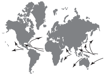
Source regions and path of hurricanes.
Excerpted from The Complete Idiot's Guide to Weather © 2002 by Mel Goldstein, Ph.D.. All rights reserved including the right of reproduction in whole or in part in any form. Used by arrangement with Alpha Books, a member of Penguin Group (USA) Inc.


