Weather: In the Clouds
In the Clouds
Hopefully, all this talk about humidity hasn't put you in a fog—but that's the topic we discuss next. Fog is just a cloud that has touched the ground. It's one of 10 basic cloud types, and if you master those cloud forms, you can tell quite a bit about what the weather is up to just by looking at them. The clouds decorate the sky, and the patterns tell a story.
Cloud Formation
How do the clouds get there? Well, we are experts on humidity now, and it might seem that if the humidity climbs to 100 percent over a portion or slice of the atmosphere, condensation will take place, and clouds will have no choice but to form.
Sounds good, but not so fast. There are some glitches along the way. For one, droplets are small and round. How small? About one ten-thousandth of an inch or less—microscopic. A powerful surface tension exists among the water molecules that form the small curved surfaces. Any vapor that goes into the liquid state must overcome this surface tension. That's not so easy. In fact, the force needed to overcome such tension is simply not available in the atmosphere. Left alone, water vapor would never form cloud droplets. There would never be clouds, there would never be rain, and I would be a pharmacist now like my mother wanted.
Weather-Speak
Cirrus clouds are thin, wispy, high clouds. Stratus comes from the Latin meaning "layer"; these clouds are flat and stay close to the ground. Cumulus comes from the Latin for "puffy." Those are the fleecy-looking clouds that paint the sky on a pleasant, quiet day. Nimbus comes from the Latin for "rainbearing." Any cloud that delivers rain is a nimbus cloud.
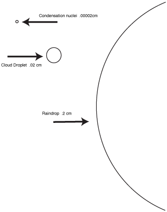
Dirt to the rescue! Or at least small, microscopic particles. Thanks to particles suspended in the air, cloud droplets are able to form. Certain hygroscopic particles, such as salt, attract water vapor. Even when the atmosphere looks crystal clear, these small particles float around us. In a volume that is no larger than an index finger, there are up to 150,000 of these particles, called condensation nuclei. Thanks to them, water vapor is able to overcome that curvature effect, condensation can take place, droplets form, and eventually, we have a rainy day. So many of these particles are present that cloud droplets can form at a relative humidity that is even slightly less than 100 percent. These particles are about one-one hundredth the size of cloud droplets and come from smokestacks, volcanoes, forest fires, and ocean spray. The following figure shows the spectrum of sizes between these tiny nuclei, cloud droplets, and raindrops.

Spectrum of atmospheric elements.
Cloud Classification
The first effort to make some order out of the patterns in the sky occurred in the very early nineteenth century. The French naturalist Lamarck first introduced a system, but shortly after an English chemist, Luke Howard, worked on a scheme that became widely accepted. Howard became known as the "father of British meteorology," and his pioneering work won him all kinds of distinctions, including having a poem written for him by Goethe. In those days, Latin was big, and Howard's system was based on four major cloud types named according to the way they looked. Toward the end of the century, Howard's original system was expanded into 10 principal cloud forms. That classification scheme has remained essentially unchanged for the past 100 years.
The four basic cloud types are cirrus, stratus, cumulus, and nimbus. Cirrus comes from the Latin for "thin," "wispy," or "curl of hair." And that is how cirrus clouds appear from the ground. Sometimes they are called mare's tails. They are high clouds, consisting of ice crystals because they are at elevations of 20,000 feet and higher. At those heights, water droplets freeze into ice crystals. These clouds often tell us that change is on the way. A storm may be approaching, or warmer air could be knocking on the door. Stratus comes from the Latin meaning "layer." These clouds are flat and stay close to the ground. Cumulus comes from the Latin for "puffy." Those are the fleecy-looking clouds that help paint the sky on a pleasant, quiet day. But these clouds are noted for their strong vertical development. They can form towers, and when they do, watch out. The sky can open up into a violent thunderstorm. Nimbus comes from the Latin for "rain-bearing." Any cloud that delivers rain is a nimbus cloud.
These are the four basic cloud types. There are also combinations that show up at different elevations. The classification scheme that so far has been based solely on a cloud's appearance now becomes a little more sophisticated. The types are combined and categorized into groups of high, middle, low clouds, and clouds that extend through all elevations.
Weather-Wise
Since the late 1950s, clouds have been observed by satellites. Two types of satellites look down on our clouds: POES (Polar Orbiting Environmental Satellites) and GOES (Geostationary Orbiting Environmental Satellites). The POES move around the poles. The GOES provide the pictures for television weather shows. They move around the earth at the same speed that the earth rotates, so they seem to hover over one location above the earth, near the equator at a height of 23,000 miles.

Excerpted from The Complete Idiot's Guide to Weather © 2002 by Mel Goldstein, Ph.D.. All rights reserved including the right of reproduction in whole or in part in any form. Used by arrangement with Alpha Books, a member of Penguin Group (USA) Inc.


