Indiana Map: Regions, Geography, Facts & Figures
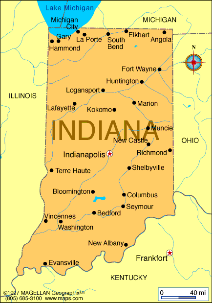
Indiana is a U.S. state located in the Great Lakes region of North America. It is known as "The Hoosier State" and is home to many major cities, including Indianapolis, the state’s capital city, located in the Indiana county of Marion. The state is bordered by Michigan to the north, Ohio to the east, Kentucky to the south, and Illinois to the west.
If you want to discover more in-depth information on Indiana as a state, check out our Indiana Profile!
Plus, test your country knowledge with our U.S. geography quiz on American Revolution Locations!

History of Indiana
Indiana has a rich history, having become a state on December 11, 1816. During the Civil War, Indiana was a crucial stop on the Underground Railroad, a network of secret routes and safe houses used by African American slaves to escape to freedom in the Union and Canada.
The state is also known for its automotive industry, with the first gasoline-powered car being built in Kokomo in 1894. Additionally, Indiana has been home to several Native American tribes, including the Miami and Potawatomi, having called this land their home for thousands of years.
Geography of Indiana
The state of Indiana covers an area of 36,418 square miles and is divided into 92 counties. The state is home to the Wabash River and the Ohio River, which both provide important transportation routes. Lake Michigan also borders the state in the northwest.
The Indiana county map shows the location of its major cities and counties, including Indianapolis, South Bend, Fort Wayne, and Evansville, as well as other notable regions such as Carmel, Elkhart, Hammond, Muncie, Columbus, Crawfordsville, Delaware, Fishers, Gary, Goshen, Greenwood, Huntington, La Porte, Noblesville, Michigan City, New Albany, Portage, Richmond, Terre Haute, Vincennes, and West Lafayette. The state is also home to several interstate highways that make access easy when traveling between cities.
Tourist Attractions in Indiana
Among other U.S. states, Indiana is a great place for visitors, adventurers, and family tourists to experience. Some of the most popular activities in Indiana include the following.
Indianapolis Motor Speedway
The Indianapolis Motor Speedway is a must-visit for any racing fan, as it is home to the famous Indy 500 race. Visitors can take a tour of the track, visit the museum, and even drive a race car.
Indiana Dunes National Park
Located on the southern shore of Lake Michigan, Indiana Dunes National Park features 15 miles of beaches and sand dunes, making it a popular spot for swimming, sunbathing, and hiking.
Children's Museum of Indianapolis
The Children's Museum of Indianapolis is the largest children's museum in the world and features interactive exhibits on science, history, and culture.
Brown County State Park
Brown County State Park is located in the hills of the southern Indiana state map and is a popular spot for hiking, camping, and fishing. Visitors can also take a scenic drive through the park's colorful autumn foliage.
Indiana State Museum
Located in downtown Indianapolis, the Indiana State Museum features exhibits on the state's history, culture, and natural resources. Visitors can learn about everything from the state's prehistoric animals to its modern-day sports heroes.
People Also Ask...
If you're inspecting the map of Indiana, you may have some queries about the region. Here are some of the most frequently asked questions, along with their answers.
Where in USA Is Indiana?
Indiana is a state located in the Great Lakes region of North America. It is bordered by Michigan, Ohio, Kentucky, and Illinois, and is known for its culture, history, natural landmarks, and visitor attractions.
What Is Indiana Most Known For?
Indiana is known for its rich history, including its role in the Underground Railroad and its automotive industry. It is also home to popular tourist sights such as the Indianapolis Motor Speedway and Indiana Dunes National Park, and the prestigious Indiana State University.
Is Indiana Considered North or South?
Indiana is considered a state in the Midwestern region of the United States, with Michigan to the north and Kentucky to the south.
|
|


