Democratic Republic of the Congo Map: Regions, Geography, Facts & Figures
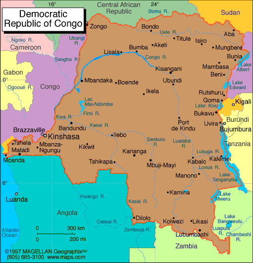
The Democratic Republic of the Congo (DRC), also known as DR Congo, DROC, Congo-Kinshasa, or simply the Congo, is a country located in Central Africa. It is the second largest country in Africa after Algeria. The country is bordered by Angola, Tanzania, Uganda, Rwanda, Burundi, Zambia, South Sudan, the Central African Republic, and the Atlantic Ocean. The capital of the DRC is Kinshasa, which is also the country's largest city.
If you want to discover more in-depth information on the DRC as a country, check out our Democratic Republic of the Congo Profile!
Plus, test your country knowledge with our African geography quiz, Can You Name These African Landmarks?
 |
|
History of the Democratic Republic of the CongoThe DRC was formerly known as Zaire and was a colony of Belgium until 1960, when it gained independence. The country has a history of political instability and conflict, including the First Congo War (1996-1997) and the Second Congo War (1998-2003). The latter involved multiple countries and is sometimes referred to as the African World War. The DRC has also experienced issues with deforestation and the exploitation of natural resources, along with other regions on the map of Africa. What Is the Difference Between DR Congo and Republic of Congo?The Democratic Republic of the Congo (DRC) and the Republic of the Congo (ROC) are two separate countries in Africa. The DRC is significantly larger than the ROC and has a much larger population. The two countries are often referred to as Congo-Kinshasa (DRC) and Congo-Brazzaville (ROC), respectively. Despite their shared history and similar names, the two countries have distinct cultures, languages, and governments. Geography of the Democratic Republic of the CongoThe DRC is a country with fascinating geography. It is home to the Congo River, which is the second longest river in Africa and the ninth longest in the world. The river flows through the country from Kisangani in the north to Matadi in the west, emptying into the Atlantic Ocean. The country also contains the Congo Basin, which is the world's second largest rainforest. Other notable geographic features of the DRC include Lake Tanganyika, the Ubangi River, and the Uele and Kasai Rivers. The political map of the country is divided into 26 provinces, including North Kivu, South Kivu, Ituri, Katanga, and Kasai. Tourist Attractions in the Democratic Republic of the CongoThe Congo country map has several tourist attractions, including national parks and nature reserves. Virunga National Park, located in the eastern part of the country, is home to rare mountain gorillas and is a UNESCO World Heritage site. Other Congolese national parks in the DRC include Garamba National Park and Kahuzi-Biega National Park. The country also has several historic sites, including the colonial-era city of Matadi, the copper mining city of Lubumbashi, and the city of Bukavu, which is located on the southern shore of Lake Kivu. The DRC: Major CitiesTo get a better sense of the geography and political divisions of the Democratic Republic of Congo, it's helpful to refer to a country map. Some of the major cities in and around the DRC include:
People Also Ask...If you're inspecting the Democratic Republic of the Congo map, you may have some queries about the region. Here are some of the most frequently asked questions, along with their answers. What Country Did the Congo Belong To?The Congo was initially a colony of Belgium from 1908 to 1960. It gained independence in 1960 and became the Republic of the Congo. Is Republic of Congo a Rich or Poor Country?The Republic of the Congo is generally considered to be a low-income country. Its economy is largely reliant on its natural resources, including oil, timber, and minerals. However, the country has faced significant challenges with corruption and governance, which have contributed to poverty and inequality. Why Is It Called the Congo and Not Just Congo?The country is named after the Congo River, which flows through the western part of the country and forms part of its border with the Democratic Republic of the Congo. The river was named by Portuguese explorers in the 15th century and is derived from the Kikongo language word "nzadi", meaning "river". |
|
|
More on Democratic Republic of the Congo: More: Countries of the World · World Geography · World Statistics · Flags |
Related Content
|


