South Africa Map: Regions, Geography, Facts & Figures
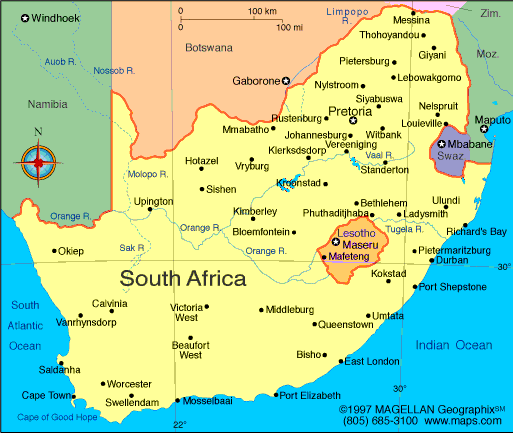
South Africa is a stunning country in Southern Africa with a population of over 59 million people in 470,693 square miles. It is renowned for its diverse cultures, breathtaking landscapes, and rich history. From the rugged coastline to the stunning Kruger National Park, South Africa is a must-visit destination for any traveler. The country's vibrant major cities, including Cape Town, Johannesburg, and Durban, offer a unique blend of modern and traditional cultures, making it an exciting and intriguing place to explore on the world map.
If you want to discover more in-depth information on South Africa as a country, check out our South Africa Profile!
Test your country knowledge with our South African geography quiz, African Flags!

South Africa: History
South Africa has a rich and complex history that spans back thousands of years. The first humans lived in the region over 100,000 years ago, and the area was later colonized by Europeans in the 17th century. It was also the site of apartheid, a system of racial segregation and discrimination that was enforced by the government until the 1990s. Today, South Africa is a diverse and vibrant democracy with a rich cultural heritage.
Nelson Mandela
Nelson Mandela is one of the most famous South Africans in history. He fought against apartheid and became the country's first black president in 1994. Mandela was a symbol of hope and reconciliation for many people in South Africa and around the world.
South Africa: Geography
The map of South Africa is bordered by Namibia, Botswana, Zimbabwe, Mozambique, Eswatini, and Lesotho. It is divided into nine provinces, each with unique landscapes and cultures. South Africa has a beautiful coastline along the Indian Ocean and the Atlantic Ocean, and is home to Kruger National Park, one of the largest game reserves in Africa where iconic animals live, such as lions, elephants, and giraffes.
Some of the provinces include Mpumalanga, Limpopo, Gauteng, North West, Eastern Cape, and Western Cape, each with its own unique attractions.
South Africa: Tourist Attractions
South Africa is home to many tourist attractions, including the Drakensberg mountain Njesuthi in the KwaZulu-Natal province, Robben Island, Table Mountain, and the stunning coastline along the Indian and Atlantic Oceans. Visitors can also explore the country's vibrant cities, including Cape Town and Johannesburg, and learn about South Africa's rich cultural heritage and history which is some of the most interesting in the countries of the world. Additionally, one can visit Port Elizabeth, a coastal city located in the Eastern Cape province.

People Also Search For…
If you're inspecting country maps of South Africa, you may have some queries about the region. Here are some of the most frequently asked questions, along with their answers.
What Is the South Africa Known for?
South Africa is known for its diverse cultures, beautiful landscapes, wildlife, and history of apartheid. The country is home to many different ethnic groups, each with their own unique traditions and customs. South Africa has many natural wonders, including Table Mountain and Kruger National Park, and is also famous for its wine and diamond industries.
Why Does South Africa Have 3 Capitals?
South Africa has three major cities as capitals: Pretoria (executive), Cape Town (legislative), and Bloemfontein (judicial). This is due to the country's unique history and system of governance, which was established during the apartheid era. The three capitals are meant to represent the three branches of government and ensure equal representation for all regions of the country.
What Is the Original Name of South Africa?
The original name of South Africa was "Transvaal" and "Orange Free State" during the colonial era. These territories were later merged to form the Union of South Africa in 1910. The country gained full independence in 1961, and the name was changed to the current "Republic of South Africa."


