Antarctica Map: Regions, Geography, Facts & Figures
Antarctica is a unique continent located at the South Pole of the Earth. It is the fifth largest continent and the only one without an indigenous population. As you can see from maps of Antarctica, it is surrounded by the Southern Ocean, and it is one of the coldest, driest, and windiest places on Earth. Despite its extreme weather conditions, Antarctica is home to many research stations operated by countries such as the United Kingdom, Australia, Chile, and the United States.
If you want to discover more in-depth information on Antarctica as a continent, check out our Antarctica Profile and Southern and Antarctic Lands!
Test your country knowledge with our Antarctica geography quiz, How Well Do You Know Antarctica?
History of Antarctica
Antarctica was first discovered in 1820 by a Russian expedition, but it wasn't until the early 1900s that explorers like Roald Amundsen and Ernest Shackleton began to visit the continent. During this time, explorers were fascinated by the frozen landscapes and the possibility of discovering new land. Today, Antarctica is a hub of scientific research, with many countries operating research stations on the continent.
Geography of Antarctica
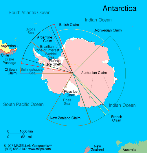
On the map of the world, Antarctica is a land like no other. It has some of the most intense weather on Earth, and it is covered by an ice sheet that is over a mile thick in some places. The continent is surrounded by the Southern Ocean, which is home to a diverse range of marine life, including whales, seals, and penguins. Antarctica also has many ice shelves, including the Ross Ice Shelf and the Filchner-Ronne Ice Shelf. The Transantarctic Mountains divide the continent into two atlas regions: West Antarctica and East Antarctica.
Antarctic Peninsula
The Antarctic Peninsula is a mountainous region in Antarctica extending towards South America. It is one of the most rapidly warming regions on Earth and is home to a variety of wildlife, including penguins, seals, and krill.
Icebergs
Icebergs are a common sight in the waters surrounding Antarctica. These massive chunks of ice break off from glaciers and ice shelves and can be a danger to ships in the area. According to satellite images, relief maps, and physical maps from NASA research, the sea ice in the area is incredibly thick and able to expand.
Tourist Attractions
Despite its harsh weather conditions, Antarctica is a popular destination for tourists who are interested in exploring the continent's unique environment.
McMurdo
McMurdo is the largest research station on the Antarctica continent map and is located on the southern tip of Ross Island. Visitors to McMurdo can learn about the scientific research being conducted on the continent and explore the station's unique architecture.
Ross Island
Ross Island is located off the coast of West Antarctica and is home to the active volcano, Mount Erebus. Visitors to Ross Island can explore the volcano there and observe its unique geological features. Additionally, the Ross Sea is a deep bay of the Southern Ocean, located near the continent's Ross Ice Shelf.
South Georgia
South Georgia is a sub-Antarctic island that is home to a variety of wildlife, including seals and penguins. Visitors to South Georgia can explore the island's rugged landscapes and observe the local wildlife.
Weddell Sea
The Weddell Sea is located in the Southern Ocean and is known for its abundance of emperor penguins. Visitors to the Weddell Sea can observe these majestic creatures in their natural habitat.
Lima
Lima, the capital of Peru, is a common starting point for tourists heading to Antarctica. From there, tourists can take a flight to Punta Arenas, Chile, and then board a ship to Antarctica.

People Also Ask...
If you're inspecting the Antarctic map, you may have some queries about the polar regions. Here are some of the most frequently asked questions about the Antarctic region, along with their answers.
What Is the Antarctic Circle?
The Antarctic Circle is an imaginary circle around the Earth in the southern hemisphere, located at approximately 66.5 degrees south latitude.
What Are the 12 Countries in Antarctica?
Antarctica is a continent that is uninhabited by humans, but it is often used as a site for scientific research. There are no permanent residents in Antarctica, but there are a few dozen research stations. There are 12 countries that have signed the Antarctic Treaty, which designates the continent as a scientific preserve. These countries are Argentina, Australia, Chile, France, New Zealand, Norway, Russia, South Africa, the United Kingdom, the United States, China, and Japan.
Where Is Antarctica Exactly Located?
Ice-covered Antarctica is located at the southernmost point on Earth, surrounding the South Pole. It is the fifth largest continent, covering an area of about 14 million square kilometers. The continent is surrounded by the Southern Ocean and is almost entirely covered by ice that averages at least one mile in thickness.
How Big Is Antarctica Compared to Africa?
Antarctica is a large continent, covering an area of about 14 million square kilometers, which is roughly 1.5 times the size of the United States. In comparison, Africa is the second largest continent, covering an area of about 30.2 million square kilometers, which is over twice the size of Antarctica.
What Is the Arctic?
It is important to note that Antarctica is not to be confused with the Arctic, which is located at the opposite end of the Earth and is instead made up of the Arctic Ocean and surrounding landmasses, including parts of North America, Europe, and Asia.
|
|
 |
Trending
Here are the facts and trivia that people are buzzing about.


